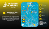
Ski touring trail La Serpentine


Presentation
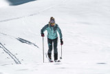
The route starts with a climb in the heart of the forest with some great views over the valley. A climb without conversions with several technical parts on the first part.
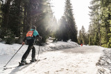
After crossing a dense forest, you will cross more open areas to reach the finish at Plaine Dranse. The descent is then made via the red piste of Les Rochassons or the green piste of La Belette.
The last descent must be made before 4.30pm.
This is a fairly difficult route.
The last descent must be made before 4.30pm.
This is a fairly difficult route.
The departure of the trail is located at Pré la Joux. Access by car, big car park on site, or by shuttle line 1 stop "Télésiège de Pré la Joux".
OpeningsFrom 20/12/2025 to 19/04/2026 daily.
(dates to be confirmed).
Subject to snow conditions.
(dates to be confirmed).
Subject to snow conditions.
Practical informations
- Levels of sporting experience :
- Level red – hard
- Route :
- daily duration (minutes) 180
- type of route Aller / Itinerance
- marked route
- elevation (m) 341
- distance (km) 6
- Additional openings :
- Subject to snow conditions
- Documentation language(s) :
- English
- French
- Dutch
Category
- Section :
- Sport
- Skiing :
- Skiing
- Ski touring route
Tarifs
Free access.
We also suggest...


Contact us
Ski touring trail La Serpentine
Domaine skiable de Plaine Dranse
74390
Châtel
Phone : +33 4 50 73 35 99
Location
The departure of the trail is located at Pré la Joux. Access by car, big car park on site, or by shuttle line 1 stop "Télésiège de Pré la Joux".